Wednesday, July 13, 2011

Hiking 2.0 : Monsoon mania to Mullayanagiri


We had joy, we had fun, we had seasons in the sun.
But the hills that we climbed
were just seasons out of time.

It was a friday afternoon and a call from Bishu changed my plans for the weekend. All the plans of sticking to my planned schedule were thrown out of the window when he wanted to do a trek, after I jokingly suggested so. Since we were open to trekking anywhere in western ghats, we decided to do the Mullayanagiri-BabaBudangiri leg after havin already done Kemmanagundi-BabaBudangiri two years earlier. So, cancelled everything and booked the overnight tickets. But fate and Mallya's creation scripted a different story and we ended up instead catching the Rajhamsa bus at 11.00 AM next day to Chikmagalur. After a brief stopover for lunch at a place after Channayarapatna, we reached Chikmagalur at 5.00 PM sharp.


Mullayanagiri (Kannada: ಮುಳ್ಳಯ್ಯನಗಿರಿ) (also spelt Mullayangiri or Mullainagiri), is the highest peak in Karnataka, India. Mullayanagiri is located at 13°23′26″N 75°43′18″E in the Baba Budan Giri Range of the Western Ghats. With a height of 1,930 metres (6,330 ft), it is the highest peak between the Himalayas and the Nilgiris

There are two routes to go to Mullayanagiri. One is a tar road that ends in a clutter of 500 steps that leads to the temple. And the other non-obvious one is to get down at Sarpadhari and take the route snaking up the hills. Its a quick ascent with a fast rate of elevation. Since tar roads are not what you want to walk on after travelling 280 kms, we asked the auto guy to drop us off near the metal arc at Sarpadhari.


It was 5.45 PM and a light drizzle started just as we were about to start. Lack of fitness showed on both as we panted throughout our initial climb till the body warmed up. Once that was done, we took minimal breaks to survey the elevation as well as the approaching darkness. I had accounted for trekking in total darkness in the plan. But we bettered ourselves in the latter bit and reached the summit by 7.05 PM, a decent speed on the slippery slopes at this time of the year.


We looked around the compound to find 3 houses and a temple at the top of the mountain. After asking the permission from the priest of the temple, we began to setup the tent. The priest offered us a room inside but it is no fun sleeping inside a house on a trek. So, we decided to set camp and it took us almost similar time as it took to climb the peak. The heavy winds had already started and we had to use huge stones to protect the pegs. Finally done by 8.30 PM, we decided to go for some socializing and went inside the house to have some black coffee(not due to choice but due to lack of milk). Met a cop there, who is stationed on a rotating basis for 4 days. He was on this shift and used to stay in the same house.

The next hour was a fun conversation with the two of them. When people don't know each other's languages, its mostly the signs and common sounding words that come to the rescue. Moreover, due to DD being the only channel on the TV, they used to watch Hindi tv soaps as well, which helped us here. Ultimately, its the language of humanism that binds us all together and we made a decent conversation before they went for dinner. We refused dinner as we were already carrying our stuff.

It was a spectacle with below 10 degree temperatures, heavy winds and mist engulfing the entire mountain. Food was cold but nevertheless attacked with glee by both of us till the last bhindi. Made some necessary calls and then indulged in bakaar till Bishu went asleep and I was left wondering how to pass the time.

Like all bad times, the night turned out to be very long. With rains, the ground had become wet. The winds never abated. The cold became worse.The tent door flapped entire night. But, finally lights came out albeit full surrounded by fog. The fog and the winds never abated till 8.00 AM. We decided to leave the place at 9 after breakfast.

The initial route to BabaBudangiri from behind the temple is a little confusing. But the right way is to go parallel y to the road and then get onto the mountain ridge. From then on, its a hike up and hike down. Except a few dangerous climbs on big wet rocks right at the edge of 30-40 feet drops, the route is not that tough. The walking trail ends near a check-post where it crosses the tar road. From there on the second leg starts towards BabaBudangiri.


It did not take us long to reach the check-post, within an hour. After some clicks and monkeying around the post, we decided to move ahead further. This latter part was a little tiring with climbs and mist reducing visibility to less than 10 meters, we just decided to follow the trail and could not make out our position in the overall route as the transmission towers(which serve as landmarks) were blocked by the mist. After more monkeying around, more snaps and more rests, we made it to BabaBudangiri by 12.30 PM, a neat time of 3.30 hours since start. On the way down, we came across a few people asking about the duration/toughness of the trek.

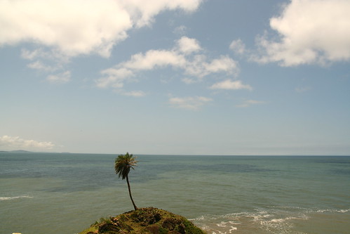
A few snaps across this trek:


Our plan was to take the 2300 hours bus from Chikmagalur, but due to our pace we reached BabaBudangiri early and hence decided to hitch hike on a Maruti omni and reached Chikmagalur bus stand at 2.45 PM right in time for the Rajhamsa bus 15 minutes later. Soon, we were on our way back and enjoying the coziness of our homes by 9.00 PM.

A weekend well spent.

Things to carry during monsoon:

1. Backpack rain cover
2. Poncho
3. A sturdy tent

The route to BabaBudangiri is a well laid out single trail. On top of the peaks, the trail sometimes disappears but try going to the other side of the top and one will find the single trail reappearing again. No leeches and quite doable even in peak monsoons. Off course the trade off would be some awesome views whitened out due to mist. More importantly don't take the wrong left from Mullayanagiri. We almost did that and came across a carcass and was about to enter a big forest till we decided to go the other way parallel y to the tar road.

Monday, January 10, 2011

Paradise lost?


7 months of B-school grind killed the bug of photography but not the travelling one...

So, when the opportunity came during the year-end break, I latched onto it and decided to go to Bangalore. Of course there were other plans but destiny has its own of playing out things. So, took the 29th evening train to Howrah and a flight next day to Bangalore.

Met near and dear ones but the bug was getting worse and finally I succumbed to it as I hit the road to Gokarna, 480 kms away from Bangalore. For more information on Gokarna.

Cut to 8.30 AM, and I was near the Hotel Gokarn and savored the sights and sounds as I walked towards Gokarna beach. 20 mins more and I met the rest of the Gang keeping the hotel cook busy, gorging on anything coming their way.

Started from Gokarna beach and took the path running to Arabian Sea towards Kudle. But this time we decided to follow the unconventional route generally followed by cows or goats rather than the locals or tourists or hikers. The route starts behind the Ganpati temple, circles dangerously around the edges of the cliffs before hitting Kudle beach. Thorns greet you at multiple places followed by the typical weird characters that makes Gokarna mysterious and inviting.


It was almost noon as we reached Kudle after some minor hiccups. We decided to hit the Sunset cafe, shack right at the middle of Kudle for some energy drinks. But as law does it to you at the most righteous of times, sale of alcohol was banned till midnight due to local elections.

After sipping something of a compromise between Balaji (a local cola found near Kudremukh) and Pepsi, we started towards OM beach on a more normal route this time.

The OM beach is so named as its shape resembles the Hindu letter 'OM'.


OM beach was a sight for sore eyes. Quite a lot of changes have happened since the time I first came here while backpacking through the western coast. Saw banana boats, speed boats, extended Indian families littering the beach. We made a quick exit from this beach, with half of the junta deciding to take the boat to Paradise and the remaining , the hour long trek across 3 more hills. As one scales up the hill at the rear end of OM, we see why its so named.


More climbing later, we take a deviation to reach the palm tree that juts out of the cliff and overlooks the Arabian Sea.


From the archives:

aaah..no not carribean


After spending about half an hour, we made our way towards half-moon beach, the name coming from as you might have already guessed, the shape of the beach.

Another 20 minutes and we came to Paradise or full-moon beach.

We went to our regular 2nd cafe(the 3rd consecutive year), owned by Nagesh and named as the Evergreen cafe.


Lots of wait and lots of food later, a few to sleep, a few went to water, a few went to shoot and the remaining did the most common activity on that beach, i.e. did NOthing.


Paradise is rumored to be so named by the Israeli hippies who found this beach in the late 70's. Its accessible by boat only till sunset, when the tide is too high for boats to come. The nearest bus stop is about 4 kms from away in Belekhan village and the last bus is at 5 PM. So, after dusk, the only route is via climbing 3 hills and trying to avoid slippery rocks :). Luckily, this very relative difficulty of accessibility kept the beach away from the footfalls of the Indian visitors for quite a long time , till almost 2 years back, when me along with a couple of my colleagues were the only Indian non-locals on the beach. But times have changes, so has the demographics. And so has the litter and respect of individual-space levels. However, the beach is still a must-go because of its relatively less density even on the new year.


Although the hippies are long gone, the beach is still heaven for backpackers and trippers, who like to spend a few weeks on lesser crowded beaches, practising yoga and stuff.


The last sunset of the year was awesome due to clear skies.


The last boat to the mainstream...


And then people let out their joy....


And some more joy...


After sunset, the entire group of 13(not very unlucky with Rags dropping out at last moment) sat around the table, chit-chatting... bottles were readied, starters ordered...cork came out and so did the fizz....cops made their appearance too... surely, the times have changed now, I felt...The music became subdued with more of rock than shiv or Goa trance this time...

The darkness outside, the sea behind our backs, a long awaited get-together made up for all the tiredness...The clock struck 12 and we were on the other side of the beach and unlike earlier times, this time it was a few shouts and everybody went back to their businesses :(

And more orders followed and after dinner a walk-up-the-hill-to-gaze-at-the-stars followed and the clear sky did not disappoint us....with the lighthouse interfering periodically.

Soon, we hit the sack at around 2, remarkably early for 31st nights...

Post-early morning activities and a breakfast at Shanti Garden, Bishu, Prasanna and myself went out to find the lighthouse and after two ascents up two hills and chasing down trails to dead-ends, we gave up and returned back to base...


The group(excluding me)


Post-lunch, I decided to start back for Gokarna as ferries were going only to OM beach due to high tides in Gokarna... Had a quick look around OM beach and found a high speed Internet cafe of all things...maybe the proverbial last straw...Just for the info, the speed was real good as I updated my facebook status...so much for my rant at materialization ...

The journey from OM to Gokarna was fun...made a couple of Spanish guys pulling their bikes up the hill...Offered them the matches to light up and shared a few moments with them, before they went to depths of Hindu mythology and culture and I made a quick exit before my poverty in knowledge of my own culture embarrassed me...

Since, I had 2 more hours to spare, went to Bahadur's place at Flower Garden and had his special French toast and cutting chai before taking the return bus to Bangalore...

More travelling followed and I reached Jampot by 10 PM...well-spent 102 hours away from there...

PS: Thanks to Chetan, Jaggu and Madhu for the pics...

PPS: Guys, time to find a new new-year destination, a new Paradise :)


Monday, April 19, 2010

Channagiri : A night out on the rocks

I was waiting for summer time
Music playing people everywhere
No need to worry the tequila is here
And when the sun goes down we are having fun
'Cause there will be a hill to trek on

Early April, the sun was blazing in namma Bengalooru and the temperature had reached above what was considered normal for the Garden city. Bishu, Vasu & me had been to Sharvathi river valley the previous weekend. So, decided to avoid travelling long distance over the long weekend of Good Friday. Since there was a meetup with GMP puys on saturday, I talked with Bishu and Rajesh and we decided on a night trek starting saturday night. I narrowed down to 3 options:

1. Makkalidurga
2. TG Halli
3. Channagiri

Since Bishu had been to Makkalidurga and SK to TG Halli, we decided to hike up Channagiri.

Saturday night after dinner, I landed up at Bishu's place. We chalked out some milestones to cross on our route to Channagiri. With the help of trekwiki we decided to take the following route:

Bangalore>Doddabalapur>Melkote>Doddarayappanahalli>Chikkarayappanahalli->Sadhu Math Village

This Melkote is after one crosses Doddaballapur and not to be confused with Melukote that comes in Mandya district.

Bishu and me started at around 2200 hours from RT nagar and reached Rajesh's house at 2230. We started around 2300 hours from Yelahanka. A tea-break after bypassing Doddaballapur and some pieces of advice of the dangers (of highway riding and such shit at night time) from a localite, who came to know of our plans, we decided to move ahead before attracting further attention. Its nice to see people worrying about you, but they don't realize the thrill and kicks that one gets out of these activities.

After driving on roads, bad roads, no roads and meeting people looking for Skandagiri, we finally managed to drag our rubbers onto Sadhu math village at around 0045 hours. A villager was sleeping on the road and we almost missed him :-) . The noise of the thumps was enough to wake up another villager, who showed us the place to park the bikes and some general information about Channagiri.

Channagiri is one of the 5 hills in the Nandi hills area. It has a height of 1445 m. The starting point of the trek, Sadhu Math is a pretty non descript village with almost 20 houses around.
According to the villager, wild boars are abound in the mountains and people come for hunting.

After the customary 1-cig salute-at-beginning-of-the-trek from Rajesh and us cursing him yet again for polluting the air, we started making our way through the rocks and the dry yet thorny shrubs. We made good progress. The descent was ok. Also the moonlight was decent enough, prompting us to switch off the torches for sometime. After half-an-hour of walking, we got a brilliant rocky slope to lie down. And so we did!. The breeze and the views of distant villages & lights were pretty alluring. But the lust for more breeze and more lights kept us going further. The second pit-stop happened after another half an hour on another such rocky slope. We soon came across some flat ground but could not see a trail in the jungle towards the peak. Here I should mention that in night treks, the objective should be to go towards the peak rather than away from it since you will mess up the trail anyway ;). And so we missed once. We ended up in a thorny and thick forest route, just when we thought that the peak was another 15-20 minutes away.

We retraced our path to see if we had missed any deviation. It was then that Rajesh wondered aloud typically that we should sleep in the nearest flat surface and attempt the peak next morning. Neither me nor Bishu reacted. I chuckled at myself wondering who will kick his ass first , and we kept retracing back till we saw the deviation. We took the deviation and after another 20 minutes of walk, we ended up at the peak of Channagiri. The watch showed 0230 hours.

We were not alone at the peak. We met a group of 4 people having tea at the shelter next to the temple. They were shocked to see 3 men at that time of the night. But then again we are used to people reacting that way ;-) After some explanations from Rajesh in kannada, they seemed secure and offered us tea. And boy, did I have the tea or what. There is one thing having coffee with a friend in a CCD back in Bangalore and another thing having tea at 3 in the morning with some strangers on a peak being hit by gusty winds. And the 2nd thing is very hard to come by in these mechanized life of ours where we end up getting accustomed to living life the normal way.

After tea, we went around the flat peak. There is a temple and a pond on the peak. Please don't rely on the pond for water. It looks full of algae. Next to the temple, we found a flat big rock slab for sleeping. It was a flat piece of rock. Winds were hitting us on the face. Skandagiri was on our left hand side and Nandi hills on the right hand side. And situated in between, we had this view.
The fully lit town is Chikballapur.

Looking in your eyes I see a paradise
This world that I found is too good to be true
Standing here beside you, want so much to give you
This love in my heart that I'm feeling for you


After a few experiments with the camera, we decided to take rest for the night or dawn should I say as it was almost 4 AM. We were well protected by our sleeping bags and had decent sleep.
My sleep was disturbed in parts by sound of quarrying from the other side of Channagiri and the noise by a few lunatics from Nandi hills side. I woke up at 5.30 AM to catch one of the most beautiful sun rises I have seen. With the peak of Skandagiri in the foreground, the colors looked mesmerizing.


After sun-rise, I again went back to sleep. Bishu was all along sleeping. Rajesh got up to take the other pictures.


At 8.00 AM, all 3 of us were up and decided to have some jumpy snaps as well as snaps with the temple.


Once done, we started on our way back. The journey back was uneventful and done at very good speed. We reached around 45 minutes of starting at the bike parking place. The machines were started and we bade adieu to Channagiri.

We then went on a long ride to Gaurebiddanaur->Doddaballapur. The weather was absolutely hot and we even tried to rest under the tree for sometime. Did not help much though.


We were back in Bangalore by 1400 hours. A saturday night well spent, I opine.

Things to note:

1. Don't leave any litter behind and make the place worse.

2. On a night trek, always go towards the peak.

3. You can avail bus to Sadhu Math village. I have seen KSRTC Sarige buses ply from Doddaballapur.

4. Please carry minimum 3 L of water as there is no water at the peak, especially during the dry season.

5. If these morons keep on quarrying, we will lose most of the hills around Bangalore.


Monday, April 5, 2010

Sharavathi valley: Veegi falls & island camping


Heat had taken a toll in Bangalore in March itself. With temperatures hovering around late 30s and tiredness still prevailing from the whirlwind Kotebetta trek, we(me & Bishu) decided to stick to a little more touristy genre and zeroed in on the easy trek and night-camping-on-a-island program that is held in Sharavathi river valley.

The Sharavathi river valley nestled in the central Western Ghats, Shimoga district has been an ecological paradise. The Sharavathi River, rising at Ambuthirtha in Thirthahalli taluk flows north-west and drops down in the Ghats at the world famous Jog falls. The Sharavathi Valley is home for many water falls and to some of the beautiful streams.

Sharavathi Backwater:- Sharavathi backwater is about 60 KM in length and about 15 KM wide !!!!. It became backwater when dam was constructed at Linganamakki of Sagara taluk in Shivamogga(Shimoga) district to the river Sharavathi. This backwater has created lots of islands, it is so great to explore all these, where thick vegetation still exist and lot of wild life in it including some rare birds.

Our partner in this trip was Vasu, who was the original project manager for this program but shelved it later because of lack of quorum among the members who rode to Maddur and decided on (not) going for the program. So, we 3 decided to go on this trip scheduled for the 27th-28th weekend of March.

The trek for the Veegi falls starts somewhere about 35km from Kargal. To reach Kargal directly from Bangalore, there is only one KSRTC Rajhamsa bus that goes to Linganamakki. We booked our travel in the bus and reached Kargal early morning at 6 AM. After sometime, Narayana joined us and told that we would have to wait for another group of 4 who had got down at Sagara. I whiled away my time by taking some random shots. The main central place of Kargal had about 20 shops dotting the road and is about 100 metres end to end.


Photo: Kargal market place

Around 7.30 AM, the other group joined us and we all boarded the Jeep(which Narayana had brought along) and started for our destination, a journey of around 35 kms. This distance was on ghat roads and the jeep driver looked a Kargali-zed version of Narain Karthikeyan, matching the latter's turns with dexterity minus the crash and pit-stops. We were at the starting point of our trek by 9 AM.

The starting point of the trek was a tribal's house, where we were treated to some fabulous Akki roti and Chutney. The breakfast was terminated by a round of tea. Here, we were joined by the cook, his helper and the jeep driver, making us a group of 11. We started for the first Veegi falls around 10.00 AM.

The initial walk was pretty easy and went over a few ups and downs, before a steep down in the jungle towards the first Veegi falls. The terrain was steep but we were helped by the dry soil that prevent slippages in mud as would have been the case in monsoon. Soon, we were at the Veegi falls, 200feet in height. The water flow, as expected, was on the lower side. But that did not prevent us from enjoying the falls one bit.


Photo: Veegi falls

We had to follow the stream below for around 5 more kms before reaching our lunch point. Since we had enough time at our disposal and the trail was pretty easy, we spent a lot of time talking, clicking and frolicking in the water. In between, we were greeted by some awesome sights.


Photo: Trail in the water


Photo: Light on the forest floor

The pace was good and soon by 12.00 PM, we were at the camping spot where rice and sambar were being cooked. The cook and his helper had left us earlier so as to make preparations for lunch. Since lunch was still an hour away, we set off for the next falls, a 10m drop with heavy flow, providing a much needed succor to our bodies once we were inside it. The 30-minute joy bath in this falls was akin to getting done a spa visit. Hunger took over soon and we went back to the cooking site. Here we met a forest survey team, which comprised of many village girls, to our horror. I was doing a savariya-style with just a white towel and Bishu, the 22nd century trekker with a UV-protected hat, sunglass and his langot, nothing else.

Lunch comprised of rice, sambar and pickle. It was devoured with glee by all of us. After a small nap, we started on our journey back. A little steep initially, the route zig-zagged in the forest. At one point, the path splits the Sagara taluk of Shimoga district and Honavara taluk of Karwar district. We covered the distance in quick time but ran out of water in the heat. So, we ended up following the guide to the tribal's house on a jeep track. This was another 4 kms away. In this section, one can see the fields and the livestock belonging to the local people.


Soon, we reached the tribal house and had loads of water. We boarded the jeep and picked up everybody on the way before starting for Kargal. Another 35kms of journey to Kargal and we drove towards Talaguppa , on the diversion from the road to Sagara. It must have been 15-20 more kms before we reached the base camp of the backwater trip. The jeep journey cost us 1800 INR. After walking a few hundred metres, we were at the place where we need to board the coracles. The sight was lovely and enchanting.


Photo: Pristine Sharavathi backwaters

My idea of a fun ride ended when it dawned that we had to paddle our way to the island. I am
pretty bad with circular objects and this was no exception. I huffed-puffed and paddled for 50 m before giving up. I got another chance to redeem myself later on, but again failed
there. It took around 45 minutes to cross this 200 m waterway.

The sun had set by the time we reached the island. We were treated to a round of bajji and a half-bucket of tea. Since I am among the ones who like to sin around, I did the same here. I had more than 0.5L of tea to make sure that tea did not get wasted. Helped by the fact that the tea was way better than I had in a very long time. It was a pretty sight: sitting on the grass, drinking tea, listening to the chirping of the birds, coolness of the evening and a lovely sight in front of you. My mind just drifted along with my senses.


The night was welcomed by a campfire right in the middle of two trees facing the backwaters. Had sleeping mats for sitting around or in the case of Bishu, sleeping around. Vasu, the dude went romantic and started playing Jagjit Singh's songs and it was a perfect setting for lazing around.


There was no mobile connectivity for Vodafone users and since I believe that "life begins where you cease to remain connected", I had a gala time gazing at the stars. Dinner ensued and we had a royal feast: rotis, bisibelle baath, sambar, curd rice and payasam. The 0.5L of tea started to cause acidity now but lived to tell the tale. We brought up a tent next to the fire place. Vasu and me decided to go for a night walk and went to a distant part of a connected island and managed to scare a "supertramp" cow(who might also have been bored with civilization and decided to spend some time off alone) not before it scared us by breaking the silence of the night.
The rest of the night was pretty normal and we woke up just in time to catch the sunrise.
Boy, it was magnificient.


Photo: Sunrise over the backwaters

Photo: Our tent and camp-site

A round of tea was followed by freshening up and breakfast. Soon, we were ready for our floating session.
With 30 mins of trying around, I mastered the way of going back :) . Soon people climbed on top of a old tree and jumped in the water. Somersaults, free-style diving, front-diving all followed.
I climbed up the tree, created a scene and did not jump for 15 minutes. It led to a huge pile-up on the tree with divers waiting for their turns, before Bishu pushed me from behind.


The time came for my favorite bit now, that is Kayaking. I sat on it and paddled for quite a long time, going around in circles, other islands. A cool breeze was blowing and in such pristine backwaters, I faced a momentary lapse of reason and just paddle around wherever I wanted to set flow. After an hour of doing this, we parked our kayaks onto an island so that others can also have fun in them. We took up a raft now, and took it around and landed on the other side of the island. We carried it on our heads to the bank on the other side of the island. Hard work done, time to again set into the water since lunch was still half an hour away.


Photo: Vasu with his kayak

Lunch comprised of pulao and kesari baath. Post-lunch, we went atop the tree house and slept like logs for sometime. After an hour, we decided to undertake the final leg of our journey - a trek to the remotest part of the island by penetrating the forests. We did it successfully and came across some amazing landscapes made by the water over the centuries. Land-carvings, steps, amphitheatre-like steps etc. were the sights of the day. Unfortunately did not have my camera at that time.

On our way back, we tried to take a different route but took too much of a right turn and landed up in a different part of the island. Sanity prevailed and we decided to circumference out the island to get back to our camping spot. Soon enough, we reached it :).

We quickly packed our bags and put it onto coracle, paddled across by Vasu. Bishu and myself enjoyed the responsibility of paddling across the two Kayaks to the mainland. Took some 15 mins before we were there at the mainland. This was followed by another swim and a walk across to the nearest bus junction, to catch the bus to Sagara at 6 PM.

The journey back was uneventful: Took Sagar-Shimoga bus, had dinner at Nandini and caught our inter-city train to Bangalore. We reached Bangalore at 0430 hours. I was home by 6 AM.

PS: It was a wonderful fun-filled trip enjoyed in a natural setting of Sharavathi backwaters.
Hope the sanctity of the place is maintained over the years to come.

PPS: Sampath and Sharvathi nature trails has been doing a wonderful job promoting eco-tourism in the Sharavathi valley, both in terms of treks and island camping. The model of involving local people to whom these forests are dear, has been successful and hope we continue to see many more new trails and places explored in this area. Also, a special thanks to Narayana and his efforts to understand my version of Kannada and replying back with his version of English while explaining tit-bits of vegetation, trails etc. :)

Tips on Travel:

1. If its trek, then there is only one KSRTC bus from Bangalore to Kargal(end point: Linganamakki)

2. If its island camping, local bus is available from Sagar.

3. On the way back, please make sure not to miss the 6 PM bus, the bus stop is 1 km from the campsite.