Monday, April 19, 2010

Channagiri : A night out on the rocks

I was waiting for summer time
Music playing people everywhere
No need to worry the tequila is here
And when the sun goes down we are having fun
'Cause there will be a hill to trek on

Early April, the sun was blazing in namma Bengalooru and the temperature had reached above what was considered normal for the Garden city. Bishu, Vasu & me had been to Sharvathi river valley the previous weekend. So, decided to avoid travelling long distance over the long weekend of Good Friday. Since there was a meetup with GMP puys on saturday, I talked with Bishu and Rajesh and we decided on a night trek starting saturday night. I narrowed down to 3 options:

1. Makkalidurga
2. TG Halli
3. Channagiri

Since Bishu had been to Makkalidurga and SK to TG Halli, we decided to hike up Channagiri.

Saturday night after dinner, I landed up at Bishu's place. We chalked out some milestones to cross on our route to Channagiri. With the help of trekwiki we decided to take the following route:

Bangalore>Doddabalapur>Melkote>Doddarayappanahalli>Chikkarayappanahalli->Sadhu Math Village

This Melkote is after one crosses Doddaballapur and not to be confused with Melukote that comes in Mandya district.

Bishu and me started at around 2200 hours from RT nagar and reached Rajesh's house at 2230. We started around 2300 hours from Yelahanka. A tea-break after bypassing Doddaballapur and some pieces of advice of the dangers (of highway riding and such shit at night time) from a localite, who came to know of our plans, we decided to move ahead before attracting further attention. Its nice to see people worrying about you, but they don't realize the thrill and kicks that one gets out of these activities.

After driving on roads, bad roads, no roads and meeting people looking for Skandagiri, we finally managed to drag our rubbers onto Sadhu math village at around 0045 hours. A villager was sleeping on the road and we almost missed him :-) . The noise of the thumps was enough to wake up another villager, who showed us the place to park the bikes and some general information about Channagiri.

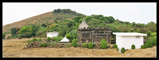
Channagiri is one of the 5 hills in the Nandi hills area. It has a height of 1445 m. The starting point of the trek, Sadhu Math is a pretty non descript village with almost 20 houses around.
According to the villager, wild boars are abound in the mountains and people come for hunting.

After the customary 1-cig salute-at-beginning-of-the-trek from Rajesh and us cursing him yet again for polluting the air, we started making our way through the rocks and the dry yet thorny shrubs. We made good progress. The descent was ok. Also the moonlight was decent enough, prompting us to switch off the torches for sometime. After half-an-hour of walking, we got a brilliant rocky slope to lie down. And so we did!. The breeze and the views of distant villages & lights were pretty alluring. But the lust for more breeze and more lights kept us going further. The second pit-stop happened after another half an hour on another such rocky slope. We soon came across some flat ground but could not see a trail in the jungle towards the peak. Here I should mention that in night treks, the objective should be to go towards the peak rather than away from it since you will mess up the trail anyway ;). And so we missed once. We ended up in a thorny and thick forest route, just when we thought that the peak was another 15-20 minutes away.

We retraced our path to see if we had missed any deviation. It was then that Rajesh wondered aloud typically that we should sleep in the nearest flat surface and attempt the peak next morning. Neither me nor Bishu reacted. I chuckled at myself wondering who will kick his ass first , and we kept retracing back till we saw the deviation. We took the deviation and after another 20 minutes of walk, we ended up at the peak of Channagiri. The watch showed 0230 hours.

We were not alone at the peak. We met a group of 4 people having tea at the shelter next to the temple. They were shocked to see 3 men at that time of the night. But then again we are used to people reacting that way ;-) After some explanations from Rajesh in kannada, they seemed secure and offered us tea. And boy, did I have the tea or what. There is one thing having coffee with a friend in a CCD back in Bangalore and another thing having tea at 3 in the morning with some strangers on a peak being hit by gusty winds. And the 2nd thing is very hard to come by in these mechanized life of ours where we end up getting accustomed to living life the normal way.

After tea, we went around the flat peak. There is a temple and a pond on the peak. Please don't rely on the pond for water. It looks full of algae. Next to the temple, we found a flat big rock slab for sleeping. It was a flat piece of rock. Winds were hitting us on the face. Skandagiri was on our left hand side and Nandi hills on the right hand side. And situated in between, we had this view.
The fully lit town is Chikballapur.

Looking in your eyes I see a paradise
This world that I found is too good to be true
Standing here beside you, want so much to give you
This love in my heart that I'm feeling for you


After a few experiments with the camera, we decided to take rest for the night or dawn should I say as it was almost 4 AM. We were well protected by our sleeping bags and had decent sleep.
My sleep was disturbed in parts by sound of quarrying from the other side of Channagiri and the noise by a few lunatics from Nandi hills side. I woke up at 5.30 AM to catch one of the most beautiful sun rises I have seen. With the peak of Skandagiri in the foreground, the colors looked mesmerizing.


After sun-rise, I again went back to sleep. Bishu was all along sleeping. Rajesh got up to take the other pictures.


At 8.00 AM, all 3 of us were up and decided to have some jumpy snaps as well as snaps with the temple.


Once done, we started on our way back. The journey back was uneventful and done at very good speed. We reached around 45 minutes of starting at the bike parking place. The machines were started and we bade adieu to Channagiri.

We then went on a long ride to Gaurebiddanaur->Doddaballapur. The weather was absolutely hot and we even tried to rest under the tree for sometime. Did not help much though.


We were back in Bangalore by 1400 hours. A saturday night well spent, I opine.

Things to note:

1. Don't leave any litter behind and make the place worse.

2. On a night trek, always go towards the peak.

3. You can avail bus to Sadhu Math village. I have seen KSRTC Sarige buses ply from Doddaballapur.

4. Please carry minimum 3 L of water as there is no water at the peak, especially during the dry season.

5. If these morons keep on quarrying, we will lose most of the hills around Bangalore.


Monday, April 5, 2010

Sharavathi valley: Veegi falls & island camping


Heat had taken a toll in Bangalore in March itself. With temperatures hovering around late 30s and tiredness still prevailing from the whirlwind Kotebetta trek, we(me & Bishu) decided to stick to a little more touristy genre and zeroed in on the easy trek and night-camping-on-a-island program that is held in Sharavathi river valley.

The Sharavathi river valley nestled in the central Western Ghats, Shimoga district has been an ecological paradise. The Sharavathi River, rising at Ambuthirtha in Thirthahalli taluk flows north-west and drops down in the Ghats at the world famous Jog falls. The Sharavathi Valley is home for many water falls and to some of the beautiful streams.

Sharavathi Backwater:- Sharavathi backwater is about 60 KM in length and about 15 KM wide !!!!. It became backwater when dam was constructed at Linganamakki of Sagara taluk in Shivamogga(Shimoga) district to the river Sharavathi. This backwater has created lots of islands, it is so great to explore all these, where thick vegetation still exist and lot of wild life in it including some rare birds.

Our partner in this trip was Vasu, who was the original project manager for this program but shelved it later because of lack of quorum among the members who rode to Maddur and decided on (not) going for the program. So, we 3 decided to go on this trip scheduled for the 27th-28th weekend of March.

The trek for the Veegi falls starts somewhere about 35km from Kargal. To reach Kargal directly from Bangalore, there is only one KSRTC Rajhamsa bus that goes to Linganamakki. We booked our travel in the bus and reached Kargal early morning at 6 AM. After sometime, Narayana joined us and told that we would have to wait for another group of 4 who had got down at Sagara. I whiled away my time by taking some random shots. The main central place of Kargal had about 20 shops dotting the road and is about 100 metres end to end.


Photo: Kargal market place

Around 7.30 AM, the other group joined us and we all boarded the Jeep(which Narayana had brought along) and started for our destination, a journey of around 35 kms. This distance was on ghat roads and the jeep driver looked a Kargali-zed version of Narain Karthikeyan, matching the latter's turns with dexterity minus the crash and pit-stops. We were at the starting point of our trek by 9 AM.

The starting point of the trek was a tribal's house, where we were treated to some fabulous Akki roti and Chutney. The breakfast was terminated by a round of tea. Here, we were joined by the cook, his helper and the jeep driver, making us a group of 11. We started for the first Veegi falls around 10.00 AM.

The initial walk was pretty easy and went over a few ups and downs, before a steep down in the jungle towards the first Veegi falls. The terrain was steep but we were helped by the dry soil that prevent slippages in mud as would have been the case in monsoon. Soon, we were at the Veegi falls, 200feet in height. The water flow, as expected, was on the lower side. But that did not prevent us from enjoying the falls one bit.


Photo: Veegi falls

We had to follow the stream below for around 5 more kms before reaching our lunch point. Since we had enough time at our disposal and the trail was pretty easy, we spent a lot of time talking, clicking and frolicking in the water. In between, we were greeted by some awesome sights.


Photo: Trail in the water


Photo: Light on the forest floor

The pace was good and soon by 12.00 PM, we were at the camping spot where rice and sambar were being cooked. The cook and his helper had left us earlier so as to make preparations for lunch. Since lunch was still an hour away, we set off for the next falls, a 10m drop with heavy flow, providing a much needed succor to our bodies once we were inside it. The 30-minute joy bath in this falls was akin to getting done a spa visit. Hunger took over soon and we went back to the cooking site. Here we met a forest survey team, which comprised of many village girls, to our horror. I was doing a savariya-style with just a white towel and Bishu, the 22nd century trekker with a UV-protected hat, sunglass and his langot, nothing else.

Lunch comprised of rice, sambar and pickle. It was devoured with glee by all of us. After a small nap, we started on our journey back. A little steep initially, the route zig-zagged in the forest. At one point, the path splits the Sagara taluk of Shimoga district and Honavara taluk of Karwar district. We covered the distance in quick time but ran out of water in the heat. So, we ended up following the guide to the tribal's house on a jeep track. This was another 4 kms away. In this section, one can see the fields and the livestock belonging to the local people.


Soon, we reached the tribal house and had loads of water. We boarded the jeep and picked up everybody on the way before starting for Kargal. Another 35kms of journey to Kargal and we drove towards Talaguppa , on the diversion from the road to Sagara. It must have been 15-20 more kms before we reached the base camp of the backwater trip. The jeep journey cost us 1800 INR. After walking a few hundred metres, we were at the place where we need to board the coracles. The sight was lovely and enchanting.


Photo: Pristine Sharavathi backwaters

My idea of a fun ride ended when it dawned that we had to paddle our way to the island. I am
pretty bad with circular objects and this was no exception. I huffed-puffed and paddled for 50 m before giving up. I got another chance to redeem myself later on, but again failed
there. It took around 45 minutes to cross this 200 m waterway.

The sun had set by the time we reached the island. We were treated to a round of bajji and a half-bucket of tea. Since I am among the ones who like to sin around, I did the same here. I had more than 0.5L of tea to make sure that tea did not get wasted. Helped by the fact that the tea was way better than I had in a very long time. It was a pretty sight: sitting on the grass, drinking tea, listening to the chirping of the birds, coolness of the evening and a lovely sight in front of you. My mind just drifted along with my senses.


The night was welcomed by a campfire right in the middle of two trees facing the backwaters. Had sleeping mats for sitting around or in the case of Bishu, sleeping around. Vasu, the dude went romantic and started playing Jagjit Singh's songs and it was a perfect setting for lazing around.


There was no mobile connectivity for Vodafone users and since I believe that "life begins where you cease to remain connected", I had a gala time gazing at the stars. Dinner ensued and we had a royal feast: rotis, bisibelle baath, sambar, curd rice and payasam. The 0.5L of tea started to cause acidity now but lived to tell the tale. We brought up a tent next to the fire place. Vasu and me decided to go for a night walk and went to a distant part of a connected island and managed to scare a "supertramp" cow(who might also have been bored with civilization and decided to spend some time off alone) not before it scared us by breaking the silence of the night.
The rest of the night was pretty normal and we woke up just in time to catch the sunrise.
Boy, it was magnificient.


Photo: Sunrise over the backwaters

Photo: Our tent and camp-site

A round of tea was followed by freshening up and breakfast. Soon, we were ready for our floating session.
With 30 mins of trying around, I mastered the way of going back :) . Soon people climbed on top of a old tree and jumped in the water. Somersaults, free-style diving, front-diving all followed.
I climbed up the tree, created a scene and did not jump for 15 minutes. It led to a huge pile-up on the tree with divers waiting for their turns, before Bishu pushed me from behind.


The time came for my favorite bit now, that is Kayaking. I sat on it and paddled for quite a long time, going around in circles, other islands. A cool breeze was blowing and in such pristine backwaters, I faced a momentary lapse of reason and just paddle around wherever I wanted to set flow. After an hour of doing this, we parked our kayaks onto an island so that others can also have fun in them. We took up a raft now, and took it around and landed on the other side of the island. We carried it on our heads to the bank on the other side of the island. Hard work done, time to again set into the water since lunch was still half an hour away.


Photo: Vasu with his kayak

Lunch comprised of pulao and kesari baath. Post-lunch, we went atop the tree house and slept like logs for sometime. After an hour, we decided to undertake the final leg of our journey - a trek to the remotest part of the island by penetrating the forests. We did it successfully and came across some amazing landscapes made by the water over the centuries. Land-carvings, steps, amphitheatre-like steps etc. were the sights of the day. Unfortunately did not have my camera at that time.

On our way back, we tried to take a different route but took too much of a right turn and landed up in a different part of the island. Sanity prevailed and we decided to circumference out the island to get back to our camping spot. Soon enough, we reached it :).

We quickly packed our bags and put it onto coracle, paddled across by Vasu. Bishu and myself enjoyed the responsibility of paddling across the two Kayaks to the mainland. Took some 15 mins before we were there at the mainland. This was followed by another swim and a walk across to the nearest bus junction, to catch the bus to Sagara at 6 PM.

The journey back was uneventful: Took Sagar-Shimoga bus, had dinner at Nandini and caught our inter-city train to Bangalore. We reached Bangalore at 0430 hours. I was home by 6 AM.

PS: It was a wonderful fun-filled trip enjoyed in a natural setting of Sharavathi backwaters.
Hope the sanctity of the place is maintained over the years to come.

PPS: Sampath and Sharvathi nature trails has been doing a wonderful job promoting eco-tourism in the Sharavathi valley, both in terms of treks and island camping. The model of involving local people to whom these forests are dear, has been successful and hope we continue to see many more new trails and places explored in this area. Also, a special thanks to Narayana and his efforts to understand my version of Kannada and replying back with his version of English while explaining tit-bits of vegetation, trails etc. :)

Tips on Travel:

1. If its trek, then there is only one KSRTC bus from Bangalore to Kargal(end point: Linganamakki)

2. If its island camping, local bus is available from Sagar.

3. On the way back, please make sure not to miss the 6 PM bus, the bus stop is 1 km from the campsite.

Wednesday, March 17, 2010

Kotebetta : Return of the 3 idiots

These lowlands
Are a home now for me
But my home is the mist covered mountain
And always will be

Its been almost 2 months (since the new year Thadiyendemol trek) that we 3 (Bishu, Manas & yours truly) had been on a trek together. After Ombattu Gudda, I was longing for a quiet trek, with beautiful sceneries, easy walk and lots of photography. I was thinking of Jenkal & Dipadkallu betta but since we had only one day to spare, the location turned to Coorg, the decision helped in no small measure by our lust for 'pandhi curry'. Since Thadiyendemol (1752m) & Pushpagiri(1712m) have already been conquered a few times, my sights set on Kotebetta, a day trek and the 3rd highest peak in Coorg district with a height of 1640m.

Kotebetta lies near to the border between the Dakshina Kannada and Coorg districts. The trek starting point is junction near by a bridge called Hattihole. The peak is at a distance of 11km from Hattihole bridge. There is a Shiva temple on the base of Kotebetta. The trek trail passes through lot of coffee estates. Hattihole comes on the Madikeri-Somwarapet road, around 20 km from Madikeri. The trail changes from a tar road to a jeep trail to a walking trail.

Saturday morning, I was carrying over a mini-hangover(after a friday night session with CB celebrating KKR's win against DC) till PC called and wanted to go for a photoshoot to Lalbagh. Shared some gyaan with her on composition etc. and rushed home to pack my bag. I made my way to the Mysore road satellite bus stand, from where buses to Coorg leave. Our bus was at 2300 hours and soon enough Bishu & Manas appeared. I beared the initial heat of ditching them on the OG trek and then caught up over events in the last 2 months.

2300 hours: the bus meandered through the roads of Bangalore, but our banter ranging from Ivory Coast & Drogba to Kayaking plans, continued till late into the night. Our bus was a Rajhamsa executive bus, which lacked the rubber between the windows. I discovered this when I was about to sleep. Needless to say, I spent the late night moments trying to evade the cold in futility.

0515 hours: I was as miserable as the Poms are in the initial part of the English summer. We got down at the Madikeri bus-stand. The bus to Hattihole leaves at 0630 hours from the KSRTC bus-stand. The bus leaves for Sakleshpura via Somvarapet. This bus ride is akin to a roller coaster ride gone wrong with the driver sticking to the KSRTC Sarige pledge of making sure that the passengers maintain faith in the Almighty. In between, we also get to see the fantabulous sunrise over the coffee-estates enroute to Hattihole.

0730 hours: After about an hour, we were at the bridge. The hotel Hattihole had already opened and I promptly went for a cup of coffee. We were soon on our way in the beautiful morning on the route to the left after crossing the bridge. Quiet river flowing by, birds chirping, sun rays penetrating the tree cover on the roads and with just 3 people in the group, we made good progress on our mission to find a place to clean up. After a 4km walk and a few pleasant glances(mutual) at a fashion model(who was on a photoshoot), we came across a perfect place for camping and breakfast. After freshening up, we had a heavy breakfast with bread, butter and ketchup together with boiled eggs being the flavor of the day.


0900 hours: The lazy bums in us were finally overcome as we started our hike up. The junction is around 50 metres from this waterhole. The right path leads to Kotebetta, the left also leads to Kotebetta, albeit a longer, boring path that leads to a village, Mukodlu. There is a falls , KoteArbi that can be visited on the way to Kotebetta from this longer route. We took the route on the right, a signboard screaming that the peak was 7km away.

The initial half a kilometre of the trek is on tar road, which later gives way to a jeep track. Nothing interesting about the jeep track. It crosses a few dried-up streams, with coffee estates on both sides of it. After crossing the last house on the track, we tried to take a supposed short-cut and ended up wasting some energy on scaling a 70 degree ascent in the hot sun. Better sense
prevailed and we came down. Descent turned out to be tougher with the peebles giving away at every juncture. We again started on the wider trail on the jeep track, till the jeep track takes a turn around a mountain. Soon, we came out of the forest cover and had to fend in the hot sun. We could see a huge mountain face blocking the view of Kotebetta. At this point, we abandoned the jeep track and decided to just climb towards the peak. The thing to note is there will be a few more trails, but we decided to abandon exploring in the hot sun and reach the peak asap.

The journey till then was accompanied by breaks every 30 minutes, when grapes came to the rescue as in the OG trek.

This part of the stretch is more rocky with dry grass abound. With the sun beating down, even this easy ascent took some time especially with me, who just can't seem to resist big rocks and tree undergrowths. I sneaked under a tree, while Bishu and Manas continued to make their progress towards the peak. I fell asleep till I was awakened by a few devotees coming down from the temple. They were curious and we exchanged a few pleasantries. With my broken kannada, I could manage to extract some information: peak was 30 mins away, in distance 1.5 kms away, water source is behind the temple and there is an alternate route to KoteArbi from the peak. Thanking them, I again went to sleep :-).

After another 15 mins, I woke up and gathered pace to reach the rocky sledge where Bishu & Manas were high on the breeze. But since there was no shade, we started from there and after around 50 metres, we could see the temple on the base of the Kotebetta peak.
It was a Shiva temple, with a nice compound wall running on four sides of it. The peak is visible from the temple. Surprises me of the devotion of people who climb 7-8 kms to offer prayers and perform puja every day. Maybe its faith that drives them. Also found water at the natural tanks behind the temple. The tanks are hidden by forest growth. The whole area on which the temple is built is a flat ground, where people can camp, although water will be a problem. And yes, please retain the sanctity of the temple and its surroundings by not littering the place, wearing slippers/shoes, boozing or smoking in that area.The water was not very clean and could see dead mosquitoes and insects floating in the water. But like the people who perform puja, my faith is also very strong and I did not hesitate to drink the water.

The hill behind the temple is Kotebetta. We quickly dragged ourselves up in 10 mins flat and were on the peak by 1250 hours. We did not stop and continues our way to a thick undergrowth on the peak to escape the scorching sun. It was a nice thinner growth of trees, the floor covered with dry leaves. Ideal place for sitting and having lunch, we thought. And so, we did. Bisibelle bath, Rasam & Kesari Bath were attacked royally. The remaining water was gulped. Once the stomachs were filled, discussion went to societal norms in India binding the free spirits of individuals and finally agreed on the need to take a sabbatical to do a backpacking journey across the country for a year and coming back rejuvenated :-)

Years and years I roamed,
I gazed a gazely stare,
We walked a million hills,
I must have died alone,
A long long time ago.

Around 2 hours of lazing, we were back on our feet at 1430 hours for the photo-ops. A few of them followed.
The views from the peak were hazy. But we could see Pushpagiri and the backwaters of Harangi dam from the peak. I could not take clear pictures and that brought in a little disappointment. Then a group picture followed to mark the conquer of another peak to our list.


At 1500 hours, we were back down at the temple. I filled up the water bottles. Manas & I offered our prayers at the temple and soon we were on our way down. Since it was
scorching hot and the KoteArbi is a freaking long distance away, we back traced our path from the temple on the way we came. There is another path from the temple that will take one to a forest stretch, nearby which will be a stream and a campsite. KoteArbi falls is on the way from the campsite to Mukodlu.

The descent was quite boring, made worse by the peebles and loose rock abound in the walking trail. We did not stop till we reach the last house on the jeep trail. There we stopped around 1615 hours for some chilled water and an attack on the grapes and oranges brought for the trek. After half-an-hour, we started and were at the waterhole by 1730 hours without any stoppages in between. This is the beauty of trekking with a small group of like-minded people. Good progress in less time. High performance guaranteed :-)

Ascent : 3 hours excluding breaks
Descent : 2 hours excluding breaks

A good break on the rocks above with a nice current on your back. It does not get better post-trek. We waited for the KSRTC Sarige bus which was coming back from Mukodlu. It reaches the junction between 1745 and 1800 hours and directly goes to Madikeri. We boarded the bus and after an hour of bone rattling, reached Madikeri bus stand.

Since the bus to Bangalore was at 2300 hours, we whiled away our time by doing a touristy visit to Raja Seat, 2km from the bus-stand. It started getting quite chilly and we made our way to a hotel named Coorg Cusinette(opposite to Madikeri GPO) I had researched upon in my quest for tasting authentic Kodava cuisine. We had an awesome time gulping down Akki Otti, Pandhi curry and Kolli Barthad.

Soon, we were walking down the streets of Madikeri, which becomes a ghost-town post 2100 hours. We whiled away our time till the bus started and soon we were on on our way to Bangalore.

Tired body + tired mind = good sleep.

And so it was till Kushalnagar, when a bump broke me out of sleep only to notice a PYT boarding the bus. But luck was not on my side this time and I went back to sleep again. We reached Majestic bus stand at 0515 hours. I caught a 333R volvo and was at my home by 0615 hours.

Things to note:

1. Kotebetta including KoteArbi falls is a relaxed 2-day trek in hot sun. In one-day, better to just cover the peak and avoid the long boring walk to Mukodlu. Also not sure whether the stream will have enough water.

2. Bus to Hattihole starts at 0630 hours from KSRTC bus-stand. Bus goes to Harihar via Somwarapet and Sakleshpur.

3. Bus from Mukdolu can be caught at the Kotebetta junction(4kms from Hattihole bridge) to Madikeri between
1730 and 1800 hours.

4. 2 litres of water is more than sufficient in dry season. Refilling on the way back can be done at the temple.

5. Maintain the sanctity of the temple and don't litter its surroundings.

6. Don't litter near the peak as well, could see a few bottles lying nearby.

7. Absolutely no need for a guide especially in the dry season when trails are well laid out.

8. Grade: Easy post-monsoons.
Easy+ in dry season

But if you rush it up in 1-day then tiring to say the least.

9. Its difficult to get local transport, so plan the timings of the trek accordingly if you are using public transport.

10. Kodava cuisine rocks as always!!!