Wednesday, March 17, 2010

Kotebetta : Return of the 3 idiots

These lowlands
Are a home now for me
But my home is the mist covered mountain
And always will be

Its been almost 2 months (since the new year Thadiyendemol trek) that we 3 (Bishu, Manas & yours truly) had been on a trek together. After Ombattu Gudda, I was longing for a quiet trek, with beautiful sceneries, easy walk and lots of photography. I was thinking of Jenkal & Dipadkallu betta but since we had only one day to spare, the location turned to Coorg, the decision helped in no small measure by our lust for 'pandhi curry'. Since Thadiyendemol (1752m) & Pushpagiri(1712m) have already been conquered a few times, my sights set on Kotebetta, a day trek and the 3rd highest peak in Coorg district with a height of 1640m.

Kotebetta lies near to the border between the Dakshina Kannada and Coorg districts. The trek starting point is junction near by a bridge called Hattihole. The peak is at a distance of 11km from Hattihole bridge. There is a Shiva temple on the base of Kotebetta. The trek trail passes through lot of coffee estates. Hattihole comes on the Madikeri-Somwarapet road, around 20 km from Madikeri. The trail changes from a tar road to a jeep trail to a walking trail.

Saturday morning, I was carrying over a mini-hangover(after a friday night session with CB celebrating KKR's win against DC) till PC called and wanted to go for a photoshoot to Lalbagh. Shared some gyaan with her on composition etc. and rushed home to pack my bag. I made my way to the Mysore road satellite bus stand, from where buses to Coorg leave. Our bus was at 2300 hours and soon enough Bishu & Manas appeared. I beared the initial heat of ditching them on the OG trek and then caught up over events in the last 2 months.

2300 hours: the bus meandered through the roads of Bangalore, but our banter ranging from Ivory Coast & Drogba to Kayaking plans, continued till late into the night. Our bus was a Rajhamsa executive bus, which lacked the rubber between the windows. I discovered this when I was about to sleep. Needless to say, I spent the late night moments trying to evade the cold in futility.

0515 hours: I was as miserable as the Poms are in the initial part of the English summer. We got down at the Madikeri bus-stand. The bus to Hattihole leaves at 0630 hours from the KSRTC bus-stand. The bus leaves for Sakleshpura via Somvarapet. This bus ride is akin to a roller coaster ride gone wrong with the driver sticking to the KSRTC Sarige pledge of making sure that the passengers maintain faith in the Almighty. In between, we also get to see the fantabulous sunrise over the coffee-estates enroute to Hattihole.

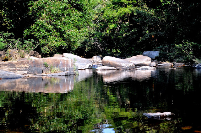
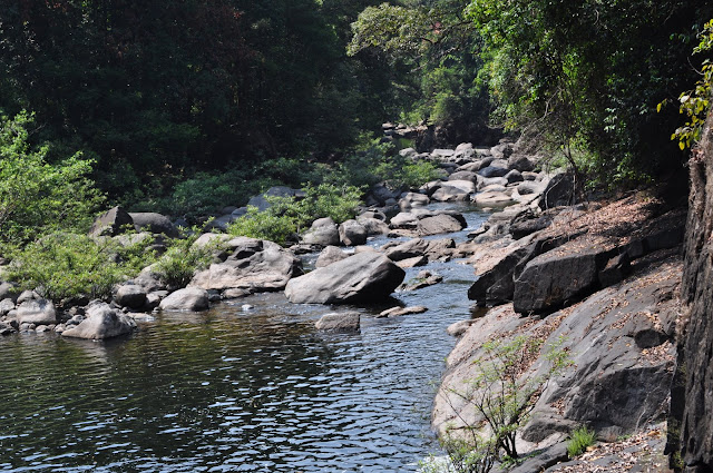
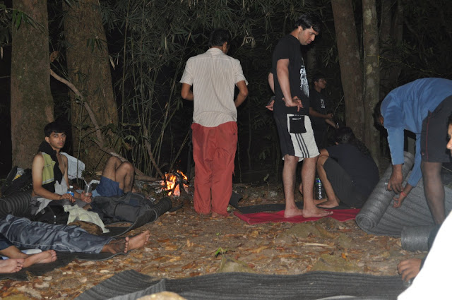
0730 hours: After about an hour, we were at the bridge. The hotel Hattihole had already opened and I promptly went for a cup of coffee. We were soon on our way in the beautiful morning on the route to the left after crossing the bridge. Quiet river flowing by, birds chirping, sun rays penetrating the tree cover on the roads and with just 3 people in the group, we made good progress on our mission to find a place to clean up. After a 4km walk and a few pleasant glances(mutual) at a fashion model(who was on a photoshoot), we came across a perfect place for camping and breakfast. After freshening up, we had a heavy breakfast with bread, butter and ketchup together with boiled eggs being the flavor of the day.


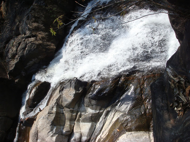
0900 hours: The lazy bums in us were finally overcome as we started our hike up. The junction is around 50 metres from this waterhole. The right path leads to Kotebetta, the left also leads to Kotebetta, albeit a longer, boring path that leads to a village, Mukodlu. There is a falls , KoteArbi that can be visited on the way to Kotebetta from this longer route. We took the route on the right, a signboard screaming that the peak was 7km away.

The initial half a kilometre of the trek is on tar road, which later gives way to a jeep track. Nothing interesting about the jeep track. It crosses a few dried-up streams, with coffee estates on both sides of it. After crossing the last house on the track, we tried to take a supposed short-cut and ended up wasting some energy on scaling a 70 degree ascent in the hot sun. Better sense
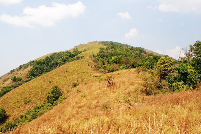
prevailed and we came down. Descent turned out to be tougher with the peebles giving away at every juncture. We again started on the wider trail on the jeep track, till the jeep track takes a turn around a mountain. Soon, we came out of the forest cover and had to fend in the hot sun. We could see a huge mountain face blocking the view of Kotebetta. At this point, we abandoned the jeep track and decided to just climb towards the peak. The thing to note is there will be a few more trails, but we decided to abandon exploring in the hot sun and reach the peak asap.

The journey till then was accompanied by breaks every 30 minutes, when grapes came to the rescue as in the OG trek.

This part of the stretch is more rocky with dry grass abound. With the sun beating down, even this easy ascent took some time especially with me, who just can't seem to resist big rocks and tree undergrowths. I sneaked under a tree, while Bishu and Manas continued to make their progress towards the peak. I fell asleep till I was awakened by a few devotees coming down from the temple. They were curious and we exchanged a few pleasantries. With my broken kannada, I could manage to extract some information: peak was 30 mins away, in distance 1.5 kms away, water source is behind the temple and there is an alternate route to KoteArbi from the peak. Thanking them, I again went to sleep :-).

After another 15 mins, I woke up and gathered pace to reach the rocky sledge where Bishu & Manas were high on the breeze. But since there was no shade, we started from there and after around 50 metres, we could see the temple on the base of the Kotebetta peak.
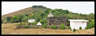
It was a Shiva temple, with a nice compound wall running on four sides of it. The peak is visible from the temple. Surprises me of the devotion of people who climb 7-8 kms to offer prayers and perform puja every day. Maybe its faith that drives them. Also found water at the natural tanks behind the temple. The tanks are hidden by forest growth. The whole area on which the temple is built is a flat ground, where people can camp, although water will be a problem. And yes, please retain the sanctity of the temple and its surroundings by not littering the place, wearing slippers/shoes, boozing or smoking in that area.The water was not very clean and could see dead mosquitoes and insects floating in the water. But like the people who perform puja, my faith is also very strong and I did not hesitate to drink the water.

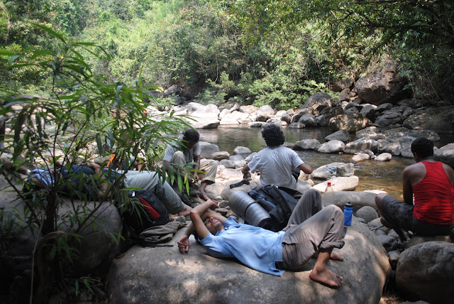
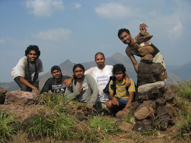
The hill behind the temple is Kotebetta. We quickly dragged ourselves up in 10 mins flat and were on the peak by 1250 hours. We did not stop and continues our way to a thick undergrowth on the peak to escape the scorching sun. It was a nice thinner growth of trees, the floor covered with dry leaves. Ideal place for sitting and having lunch, we thought. And so, we did. Bisibelle bath, Rasam & Kesari Bath were attacked royally. The remaining water was gulped. Once the stomachs were filled, discussion went to societal norms in India binding the free spirits of individuals and finally agreed on the need to take a sabbatical to do a backpacking journey across the country for a year and coming back rejuvenated :-)

Years and years I roamed,
I gazed a gazely stare,
We walked a million hills,
I must have died alone,
A long long time ago.

Around 2 hours of lazing, we were back on our feet at 1430 hours for the photo-ops. A few of them followed.
The views from the peak were hazy. But we could see Pushpagiri and the backwaters of Harangi dam from the peak. I could not take clear pictures and that brought in a little disappointment. Then a group picture followed to mark the conquer of another peak to our list.


At 1500 hours, we were back down at the temple. I filled up the water bottles. Manas & I offered our prayers at the temple and soon we were on our way down. Since it was
scorching hot and the KoteArbi is a freaking long distance away, we back traced our path from the temple on the way we came. There is another path from the temple that will take one to a forest stretch, nearby which will be a stream and a campsite. KoteArbi falls is on the way from the campsite to Mukodlu.

The descent was quite boring, made worse by the peebles and loose rock abound in the walking trail. We did not stop till we reach the last house on the jeep trail. There we stopped around 1615 hours for some chilled water and an attack on the grapes and oranges brought for the trek. After half-an-hour, we started and were at the waterhole by 1730 hours without any stoppages in between. This is the beauty of trekking with a small group of like-minded people. Good progress in less time. High performance guaranteed :-)

Ascent : 3 hours excluding breaks
Descent : 2 hours excluding breaks

A good break on the rocks above with a nice current on your back. It does not get better post-trek. We waited for the KSRTC Sarige bus which was coming back from Mukodlu. It reaches the junction between 1745 and 1800 hours and directly goes to Madikeri. We boarded the bus and after an hour of bone rattling, reached Madikeri bus stand.

Since the bus to Bangalore was at 2300 hours, we whiled away our time by doing a touristy visit to Raja Seat, 2km from the bus-stand. It started getting quite chilly and we made our way to a hotel named Coorg Cusinette(opposite to Madikeri GPO) I had researched upon in my quest for tasting authentic Kodava cuisine. We had an awesome time gulping down Akki Otti, Pandhi curry and Kolli Barthad.

Soon, we were walking down the streets of Madikeri, which becomes a ghost-town post 2100 hours. We whiled away our time till the bus started and soon we were on on our way to Bangalore.

Tired body + tired mind = good sleep.

And so it was till Kushalnagar, when a bump broke me out of sleep only to notice a PYT boarding the bus. But luck was not on my side this time and I went back to sleep again. We reached Majestic bus stand at 0515 hours. I caught a 333R volvo and was at my home by 0615 hours.

Things to note:

1. Kotebetta including KoteArbi falls is a relaxed 2-day trek in hot sun. In one-day, better to just cover the peak and avoid the long boring walk to Mukodlu. Also not sure whether the stream will have enough water.

2. Bus to Hattihole starts at 0630 hours from KSRTC bus-stand. Bus goes to Harihar via Somwarapet and Sakleshpur.

3. Bus from Mukdolu can be caught at the Kotebetta junction(4kms from Hattihole bridge) to Madikeri between
1730 and 1800 hours.

4. 2 litres of water is more than sufficient in dry season. Refilling on the way back can be done at the temple.

5. Maintain the sanctity of the temple and don't litter its surroundings.

6. Don't litter near the peak as well, could see a few bottles lying nearby.

7. Absolutely no need for a guide especially in the dry season when trails are well laid out.

8. Grade: Easy post-monsoons.
Easy+ in dry season

But if you rush it up in 1-day then tiring to say the least.

9. Its difficult to get local transport, so plan the timings of the trek accordingly if you are using public transport.

10. Kodava cuisine rocks as always!!!

Tuesday, March 2, 2010

Ombattu Gudda 3: The end of an Obsession

Into the distance, a ribbon of black

Stretched to the point of no turning back

A flight of fancy on a windswept field

Standing alone my senses reeled

A fatal attraction holding me fast, how

Can I escape this irresistible grasp?


How does a 971m peak (that too not the tallest) in a range of 9 hills become an obsession? It does when you have faced situations wherein you were not sure that

you would see civilization again. The dense forests, non-existent trails, leeches, insects of all varieties, venomous snakes, stingy scorpions, slippery rocks while walking into the river, 80 degree climbs inside forests and grasslands: you have it all during this trek. The next thing you do after failing and returning is you plot again to overcome this peak. A willingness to overcome the pain of failure and a love for spending another night in Kabbinale reserved forest range were at the heart of my desire to summit this peak.

11th of Feb, Ram sent out the mail for the trek to be organized by Bangalore Ascenders on 27th and 28th of the same month. I was unsure about joining till 3 days before the actual date, partly because of a few personal commitments and partly because of the ankle injury caused by the silly scooterist who rammed into me a couple of weeks before. But, as destiny plays out its part, X-ray revealed nothing serious and I was done with my commitments before the week was out. So, I was all set for this trek.

26th of Feb, I ran around for the supplies and was all set by 7 PM, when Khan sent out the GPS log for the 2nd route (the one that runs along the Addahole river) before it takes a deviation on left to take the forest route to the OG ridge. I downloaded the trail onto my GPS along with the first route (for backup :-o). The first route deviates from water source early and with the humidity and heat of Feb-end, not a very advisable route to take.

26th Feb, 10.30 PM: The group of 23 gathered at platform 1A of KBS. A few were excited about OG, a couple looked apprehensive . I was more worried about the

bus :-D. The bus was a Rajhamsa type. Since I booked separately and at the last moment, I paid for my procrastination with a left-window seat on the last row in the bus. My fellow last-row-mates were from a rock band, going for playing in a gig. The usual jams at Jalahalli cross and near the intersection for the flyover being constructed not withstanding, I hoped to gather some good sleep till the infamous Shiradi ghats. My hopes were dashed when I got the first bump on the road to Hassan. The road was being widened. It was a non-stop clatter for around 40 minutes. Hassan-Sakleshpur was pretty good route, except for the driver, who decided to step onto the gas and nearly hit a santro. Come Shiradi ghats, and only men with solid arses survive this test of endurance and with the driver refusing to step off the paddle, the experience separated the boys from the men. My co-sufferers in pain, the rockers, had a good time swearing at the roads, the driver and the political system :-D .


27th Feb, 4.30 AM: Addahole bridge, 1km from Gundya. Dark highway, trucks passing by, a full-moon night and then as a God-send: a tea-stall nearby. The tea was good and we waited till dawn-break to make our entry into the forest area. At around 6.50 AM, we started off for our first pitstop (the Kabbinahole river crossing) after a group photo. The weather was pleasant, the pace was good. I was at the front of the pack. Met Harish there, nice bloke, who was still sore that he looked drunk in his first tryst with fame, a picture in Bangalore Mirror, as part of the article on Bangalore Ascenders. Nothing much to say about this rather boring part of the trek. The path first crosses the village houses, then the plantations and then leads into the forest. Never take a deviation here. Just keep going on the broader trail. We reached the Kabinahole river crossing at 8.45 AM, very much on our estimated time of 2 hours for this stretch. We were joined at this point by Naresh, making the group a pack of 24. The water of the river, true to its name, was very sweet.

Photo: Courtesy - Mahesh


Photo: Courtesy - Vivek

After an hour of freshening up and breakfast, we were ready to move to our next destination, the falls created by Addahole river. At this point, we had an introduction session whereby people became aware of the others’ trek record, names etc before

we again set off. The pace of the group was very good and we were near the falls in another 45 minutes.


Photo : Courtesy - Aashna

The falls provided an ample opportunity for people to get profile pictures clicked.

Nice flat rock, beautiful falls nearby and since life is short and such views are hard to come by, we spent more time here than usual. I somehow managed to attract a couple of large butterflies, who kept on hovering over me but as life has its own way of playing out things, I had kept the camera in my bag, which was about 60m up on the trail above the waterfalls.


Soon, we moved on from the falls to the Addahole river. Here, myself & Mudassar had a few deliberations on whether to cross the river. Ultimately we decided to stick to following the river and not take diversions away from it. It turned out to be a wise decision as when I tried to walk in the forest instead of the rocks on the river bed, I got a lot of thorns and binders around me. A slight mistake on my part disturbed a few bees nearby and I hit the ground for sometime. Once I was sure they were away, I got down to join the rest of the group and did the remaining part of the river walk on the rocks.

Photo : Courtesy - Vivek


There were rocks of different sizes, and we criss-crossed the river numerous times to get around. The humidity level was very high and all of us were in deep sweat. Very soon, we came across a good clearing besides the river, with enough shade for having our lunch at 12.30 PM. People had a royal time, scavenging on the food. I dozed off after lunch, only to find half the team in the same state after I woke up.


This is what a good lunch does to you.


Photo: Courtesy - Mahesh

We started off around 1.30 PM. By this team, the sun was unbearably hot and most of us were walking in the shade whenever possible. The rocks became larger as we moved upstream. I got quite interested in a few of the bigger rocks, and tested out the Weinbrenner brand fully. The grip is awesome, dry or wet rocks, even on green fossils, especially when I was carrying the backpack which pulled/pushed me. Tried out a few difficult stunts, felt good to came off with them. One guy was not so lucky. He felt head backwards with his bag onto the river. Lucky escape, son. It could have been worse.

The team now got split into 2-3 groups as the direction was known to all and everybody moved at his and her pace. Finally after around 2.5 hours of walking, we reached a junction point where the others were sitting. Naresh and Mudassar had gone to search for the camp site. Naresh came back and we collected firewood on the way to set up a campfire. After another 20 minutes of walking, we reached the camp site, which was a little flattish ground, with thick cover of big trees but ground was clear enough to lay sleeping mats and bags.


Dinesh and myself found the big rock more appealing for the night and made that our sleeping spot. Soon, we had hot soup as appetizer. I finished a full course with rajma chawal and dal fry followed by kesari bath. Talk about surviving on meager means in the jungle :o).

The night was lovely and the fire was out by 8 PM. It was a full moon night and the sounds of the jungle took over. I did not get much sleep again, interrupted by the slide

down on the rock as well as by my habit of staying up late. The jungle looked lit with a layer of white.

28th Feb, 4 AM: I gave up on sleep now and decided to do some star gazing. Rest were fast asleep. Snoring from Dinesh was the only noise in the jungle now :-P.

About an hour later, I got up and did some stretches before the pressure turned on and I had to run with a bottle in hand. I am always wary about dry wood and rocks because of the possibility of snakes. Found a 4-feet snake :-D (too bad buddy, could not identify you, was trying to identify by the bands when you slid away) , the only wild life I encountered in this 2-day trek.

Around 6, people started waking up, freshening et al. By 7, most of us were ready and finished our breakfast. Mudassar, Naresh and myself were the first ones to move for the exploration of the deviation from the river on the right that takes one up the forest.

After a few deliberations, we kept on moving as the deviation was 300m from the camp-site and we still had not covered that distance yet. At this time, the people behind were whistling. So, I waited for them(while Mudassar & Naresh moved on) to ensure that the groups are not split. Once they were there, I took off with Ganapathy. We made very good progress but both of us ended up too far away from the group. After around 15 mins, we backtraced and came back to see a path to the left going up and Mudassar waiting nearby.

More discussions followed as I was a little apprehensive at taking the deviation earlier than what the gps trail showed. But since we would hit the ridge anyhow if we maintain the general direction of south-east for sometime, we decided to proceed. The initial jungle ascent is a little steep and that ascent later transforms into a crawling exercise where one has to employ all fours to pull one-self up. Loose rocks and thorny plants dominate this section. Best way to survive this section is to believe in your instincts only

and not anything external. So, if a rock/person is sliding down, just make way else you end up increasing the headcount. I got cut by thorns numerous times in this section of the trail, in order to take the shortest route up, a not-so-wise decision in hindsight.

However worse was in store for Ram, who unfortunately got hit by a stone and ended up with a deep cut. It took us around 30 minutes to settle down after this climb.

The forest section stretches further and takes a more north-east direction now and we end up aligning ourself towards the plotted trail. This section was much less steep and had good number of trees to hold onto and make our way ahead. I sprained my ankle here while trying to dodge a vine and this made sure that I performed the role of a sweeper till the end of the trek. Very soon, we were out of the woods and into the grasslands around 11.45 AM.


Photo : Courtesy - Mahesh

Grasslands are my worst nightmare at noon time. I along with Abhi, Hari, Adarsh, Jagy & Varun survived the worst of it. On every hump, we used to rest under a tree, even though the shade might hardly cover 2 persons. Can’t help – swalpa adjust maadi boys. Since there was enough time at our disposal, we had a royale time gulping on chocolates, grapes, dates and what not on almost each break. The views were good, but not stupendous and awe-inspiring.

The past is gone

It went by, like dusk to dawn

I know it's everybody's sin

You got to lose to know how to win

Finally, after a lot of leisurely talk, we reached the OG peak at 1615 hours. A few missed high-fives were followed by chest pumping and congratulating each other. Then the customary orkut/FB/matrimonial solo pictures followed. Lastly, a group picture of us 6 and a brief video followed. The images of previous failures and those nights in the wild with no clue what the next day will be, hovered across my mind while I was at the peak.


These brief 15 minutes at OG peak injected new life into us and we crossed the next few humps without taking any break(co-incidence that there were no trees either :o)) .

Soon, we entered the forest section and came out in 10 minutes to meet the rest of the group. They were tired and without water. Soon, a few of them came back with water from Saraswati estate and we had water to the fill.

Next up, were a few group pictures and the long walk to Lakshmi estate, 6 kms away from the start of the jeep track. Long, painful and boring walk interspersed with cool breeze and the evening coolness. We reached Lakshmi estate around 6.30 and after some really sweet tea, started on the hired bus from estate to Chikmagalur, stopping on the way for dinner in Mudigere.

Return journey was uneventful with good roads except the stretch of road widening after Hassan.

Highlights of the trek:

1. Excellent group dynamics and collaboration in each stage of the trek.

2. Good pace of the group, finished well within schedule.

3. Great soup in the evening on the first day.

4. Good organization and planning done by Ram.

5. Decisive inputs by Mudassar while making the decision to deviate at that point from the river while I thought that we should do it a little further ahead. Hats off.

6. Met quite a few interesting people in the group.

7. And the 5 amigoes as we moved from the beginning of the grassland to the end of the forest section near estate – you guys rock! Apologies if I was a little pushy on time management 

8. Hardly took any photos this time :-) . Good break after Raichur :-) trip.

9. High time a PIL is filed to close down Shiradi ghats for repair. Nobody has died of arse pain, but why take the risk?

10. Garmin GPS was like Moses :-) . It did not give up even in the thickest of forest canopies. So always go for a high sensitivity receiver GPS. And lastly, I have become a fan of Quechua backpacks now. This was the first time I used their 70-L

backpack and the carrying comfort was far better than the other reputed brands I have used.

11. OG trek is not difficult if you know the route. Its more a moderate trek. But if you don't have much idea about the route and want to decide on the ground, then be prepared for the trek of a life.

For Future trekkers:

1. Don’t venture without proper information such as maps and compass or GPS.

2. Don’t litter the trail as has already been done in bits and pieces. Carry your garbage home and burn.

3. If you want to successfully conquer OG, stick to Addahole river (2nd route) as plenty of water will be available. There will be a meeting point of another stream. From there , the deviation up is just 100m away. You can camp opposite to the deviation if only 4-5 people are there. For groups of large size, need to go further around 400m from the meeting point and 300m from the deviation up to reach a bigger camp-site.

The important coordinates to note are:

Meeting point of stream : 12degrees 55 minutes 28 seconds North
75degrees36minutes 15 seconds East

Deviation point towards forest :

12degrees 56 minutes 01 seconds North

75degrees36minutes 28 seconds East